
Schematic map
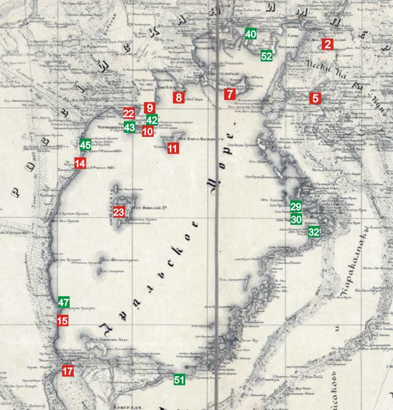
Map scheme of the Aral expedition
(places where T. Shevchenko’s drawings were made)
The map scheme is based on the map of the Aral Sea and the Khiva Khanate, drawn up by Yakov Khanikov, an active member of the Russian Geographical Society, in 1851 (using the materials of the Aral Expedition of 1848-1849). Full map (9806:16404 pixels): maps.southklad.ru.
For the "Taras Shevchenko" site, the map frame is limited to the places where Shevchenko was. It is very large (5065:5300 pixels), and all inscriptions are readable on it. It can be downloaded here (3 MB). Instead, the map shown on this page above is scaled down to 800 px and simplified (only the places where T. Shevchenko’s drawings were made are shown).
The places where Shevchenko stayed are marked with circles on the map, and the places where he made drawings are marked with squares. The red color represents the 1848 expedition, the green represents the 1849 expedition.
The expedition diary is presented by the book: V. Anisov, E. Sereda Chronicle of the life and work of T. G. Shevchenko. – K.: Dnipro, 1976 (chapter "Years of exile (1847 – 1857)"). The points named in it mostly indicate the places where the expedition was at the end of the corresponding day.
Marked with numbers
1848
June 1 – 14, 1848. A day on the shores of the Aral Sea, swimming in the Sary-Cheganak bay.
2 – June 2, 1848. The eleventh crossing of the southern part of the route (11 versts): Ak-Julpas River — Ak-Kuduk River. Drawing «Ak-Kuduk".
3 – June 3, 1848. The twelfth crossing of the southern part of the route (15 versts): Ak-Kuduk River — Sapak River.
4 – June 18, 1848. Thirteenth crossing of the southern part of the route (30 versts): Sapak River – Lake Kamyshly-Bash.
5 – June 19, 1848. The fourteenth (and last) crossing of the southern part of the route (25 versts): Lake Kamyshly-Bash — Raim Fortification. Drawings «Fort Raim. View from the shipyard on the Syr Darya", "Dock on the Syr Darya in 1848", "Schooners preparation".
6 – July 27, 1848. The expedition arrived on the island of Kos-Aral.
After the end of the voyage, on November 20, 1848, a manhunt for the tiger was conducted on the island and it was killed. Drawing «Tiger".
7 – July 7 – August 2, 1848, the expedition explored the Kug-Aral island. Drawing «Island Kug-Aral".
8 – August 2, 1848. The expedition arrived at Cape Tube-Koran and surveyed it on August 3. Drawing «Tube-Koran".
9 – August 4, 1848. The expedition arrived at the Kulanda Peninsula, where it stayed until August 9. It also returned here on August 9-11, 14-16, 1848 and July 25, 1849. Drawings "Moula-Dosa-Mal tomb on peninsula Kulandy", "Southern coast of the Kulandy peninsula".
10 – Picture «Cape Izendy Aral", performed at the same time.
11 – August 7 – 13, 1848. The expedition examined the island of Barsa-Kelmes. Drawings «Barsa-Kelmes", "Expedition tent on island Barsa-Kelmes".
12 – August 15, 1848. The expedition surveyed Cape Uzun-Kair on the Kulanda Peninsula.
13 – August 17, 1848. Anchored opposite the Singid-Takty tract (the location is shown approximately).
14 – August 20, 1848. Stopping near Cape Bai-Hubek and surveying it. Drawing «Cape Bai Gubek".
15 – August 23, 1848. Stop near the Aji-Bai tract. Picture «Adzhy-Bai".
16 – August 23, 1848. Stopping and anchoring against the Kin-Kamys tract.
17 – August 25, 1848. The expedition left from Cape Urgun-Murun to Tokmak-Ata Island. Drawing «Urgun-Murun" (wrongly dated "17"; the expedition was near Urgun-Murun on August 25).
18 – August 25, 1848. Tokmak-Ata Island.
19 – August 26 – September 6, 1848. Survey of the southern coast of the sea near Taldyk (mouth of the Amu Darya).
20 August 26 – September 6, 1848. Survey of the southern coast of the sea near the Ulu Darya (mouth of the Amu Darya).
21 – September 7, 1848. Discovery of an unknown island called Obruchev Island.
22 – September 10 – 11, 1848. Two-day stop near Cape Uzun-Kair. Drawing «West coast of Kulandy peninsula" (September 11).
23 – September 13 – 21, 1848. Stay on the newly discovered island, named Nikolay Island. Drawings «Hilly coast of Nicholas island", "Low shore of Nicholas island" and other.
24 – September 21, 1848. They explored another newly discovered island, called the Island of the Successor. From here, the expedition left for the winter on the island of Kos-Aral.
1849
25 – May 8, 1849. In the evening, they stopped against the island of Kaska-Ulan.
26 – May 9, 1849. At noon, the ship sailed from Kaska-Ulan, and in the evening anchored near the island of Kush-Jitmes.
27 – May 11 – 12, 1849. Research of shoal near the mouth of Kuvandarya and Dzhangila Island.
28 – May 13, 1849. In the morning, the schooner left from the previous berth and at 2 o’clock in the afternoon stopped near the island of Chuchka-Bas. Parking until May 16.
29 – May 17, 1849. At noon, the schooner sailed to the small island of Chikyta-Aral. Drawing «Chykyta-Aral island".
30 – May 17, 1849. In the evening, the ship approached Chekan-Aral Island. Parking until August 19. Drawing «Chekan-Aral island".
31 – May 20, 1849. They approached the shore opposite the Kungan-Sandan tract (cape).
32 – May 20 or 21, 1849. Drawing "Busaj peninsula".
33 – May 22, 1849. At dawn, they sailed from the Kungan-Sandan tract, and in the evening they stopped near the newly discovered island, which they named Menshikov Island.
34 – May 24, 1849. At 10 o’clock they saw a small island, which was named after Tolmachov.
35 – May 24, 1849. In the evening, they stopped in the sea opposite the island of Kyzil-Chaly. Parking until May 28.
36 – May 29, 1849. From Tolmachov Island, they sailed along the eastern shore and stopped at the mouth of Jalpak. Parking until June 6.
37 – On June 6, 1849, the schooner sailed from Jalpak Bay to Bish-Kum, where it stopped.
38 – June 11, 1849. In the evening, they anchored against the island of Tokmak-Ata, two miles from the mouth of the Amu Darya, and took in fresh water. On June 30, the schooner returned to the mouth of the Syr Darya.
39 – July 19, 1849. In the afternoon they sailed to Perovsky Bay, anchored for the night opposite the Kuk-Tyrnak tract.
40 – July 20, 1849. At 11 o’clock they entered the Perovsky Bay and began to survey it, which lasted on July 21 and 22. Drawings «Mountainous shore of Aral Sea", "Rocky shore of Aral Sea".
41 – July 23, 1849. At 8 o’clock in the evening, they anchored on the southern side of Cape Tube-Kara.
42 – July 24, 1849. Inspection of the Aulie stone, which looks like a sarcophagus from afar. Drawing «Tokpak-Atyse-Aulye".
43 – July 28, 1849. Surveying of the bay on the western side of the Kulanda Peninsula, which was named Chernyshov Bay. Drawing «Karzundy» (a tract on the western shore of the Kulandy Peninsula).
44 – July 29 – 30, 1849. The schooner anchored in Kum Suat Bay.
45 – July 31, 1849. After 10 hours, the schooner passed below the Kara-Tamak tract. Drawings «Kara Tamak", Kyzyl-Bulak", Kaska-Dzhul".
46 – August 3, 1849. After 3 o’clock in the afternoon, a stop near Ak-Tumsuk and astronomical observations. Drawing «Ak-Tumsuk".
47 – August 13 – 19, 1849. Anchorage against Cape Ulkun-Tumsuk. Drawing «Ulkun-Tumsuk cape".
48 – August 21 – 29, 1849. They arrived at Constantine Island. Topographic survey of the Tsar’s Islands.
49 – August 30 – 31, 1849. Survey of the newly discovered island, called Bellingshausen Island.
50 – August 31, 1849. Survey of the newly discovered island, named Lazarev Island.
51 – September 1 – 3, 1849. Observations near the Bysh-Kum tract and Ermolov Island. Drawing «Bysh-Kum".
52 – September 18, 1849. The ship headed back to the Syr Darya, but a storm forced it to stop near Cape Us-Cheka. Drawing «Us-Checka".